




Download the App & Start Learning
- Expert Faculty Guidance
- Updated Study Material
- Mock Tests & Practice Quiz
- Live Doubt Solving Sessions
- Exam-Oriented Preparation
- Motivation & Success Strategy
Katara Academy

8/10/2026
SSC GD Recruitment 2026
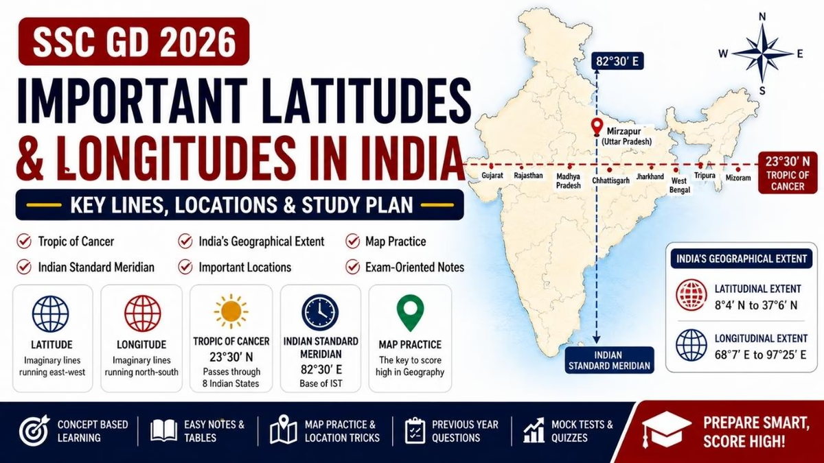
The SSC GD Important Latitudes and Longitudes in India 2026 guide covers important geographical lines, India's latitudinal and longitudinal extent, the Tropic of Cancer, Indian Standard Meridian and other location-based concepts. These topics are useful for understanding India's position on the globe and preparing for map-based Geography questions in the SSC GD Constable Examination.
Preparation Focus:
Candidates should understand the difference between latitude and longitude, remember India's geographical extent, learn the important lines passing through India and practise locating them on a map. Connecting each geographical line with the states or regions through which it passes can make revision easier.
Latitude and longitude are the basic geographical coordinates used to identify locations on the Earth. For SSC GD preparation, candidates should understand their basic meaning and focus especially on the important geographical lines associated with India.
| Particular | Details |
|---|---|
| Exam Name | SSC GD Constable Recruitment 2026 |
| Topic | Important Latitudes & Longitudes |
| Main Focus | Tropic of Cancer, Standard Meridian & Geographical Extent |
| Practice Method | Map-Based Learning, MCQs & Revision |
| Goal | Improve Geographical Location Awareness |
Before learning India's important geographical lines, candidates should clearly understand the difference between latitude and longitude. This basic concept makes it easier to understand the location of India and other places on a map.
| Latitude | Longitude |
|---|---|
| Imaginary lines running east-west | Imaginary lines running north-south |
| Measure distance north or south of the Equator | Measure distance east or west of the Prime Meridian |
| Equator is 0° latitude | Prime Meridian is 0° longitude |
| Important for understanding climatic and geographical zones | Important for determining east-west location and time |
Latitude and longitude questions are connected with basic physical geography, India's location and map-based concepts. A clear understanding of these lines can also help candidates understand India's climate, time zone and geographical position.
India's geographical position can be understood through important lines of latitude and longitude. Candidates should learn the name, degree and significance of each important line rather than memorizing the values without understanding their meaning.
| Geographical Line | Importance |
|---|---|
| Equator | Divides the Earth into Northern and Southern Hemispheres |
| Prime Meridian | Reference line for measuring longitude |
| Tropic of Cancer | Important latitude passing through India |
| Indian Standard Meridian | Reference longitude used for Indian Standard Time |
India occupies a significant geographical area in South Asia. Knowing its approximate latitudinal and longitudinal extent is important for understanding the country's position on the globe and is a useful part of SSC GD Geography preparation.
| Extent | Approximate Range | What to Remember |
|---|---|---|
| Latitudinal Extent | About 8°4′N to 37°6′N | North-South Position of India |
| Longitudinal Extent | About 68°7′E to 97°25′E | East-West Position of India |
| Time | Activity |
|---|---|
| 10 Minutes | Basic Latitude & Longitude Revision |
| 10 Minutes | Important Lines & Degrees |
| 10 Minutes | India Map Practice |
| 10 Minutes | MCQs & Quick Revision |
The Tropic of Cancer is one of the most important latitudes for SSC GD Geography preparation. It is located at approximately 23°30′ North latitude and passes through the central part of India. Candidates should remember the states through which it passes and practise locating them on an India map.
The Tropic of Cancer passes through eight Indian states. Memorizing these states in sequence can make map-based questions easier to solve.
| Order | State |
|---|---|
| 1 | Gujarat |
| 2 | Rajasthan |
| 3 | Madhya Pradesh |
| 4 | Chhattisgarh |
| 5 | Jharkhand |
| 6 | West Bengal |
| 7 | Tripura |
| 8 | Mizoram |
Instead of memorizing the eight states randomly, revise them from west to east on an India map. Repeat the sequence regularly and then test yourself by identifying the states without looking at your notes.
Gujarat → Rajasthan → Madhya Pradesh → Chhattisgarh → Jharkhand → West Bengal → Tripura → Mizoram
Practice this sequence with a blank political map of India for better retention.
The Indian Standard Meridian is an important longitude associated with Indian Standard Time. It is located at 82°30′ East longitude. Candidates should remember its degree, purpose and location.
| Feature | Important Information |
|---|---|
| Longitude | 82°30′ E |
| Purpose | Reference Meridian for Indian Standard Time |
| Reference Time | IST |
| Important State | Uttar Pradesh |
The Indian Standard Meridian passes through Mirzapur in Uttar Pradesh. Its location is commonly asked in Indian Geography and General Knowledge examinations.
82°30′ E → Mirzapur, Uttar Pradesh → Indian Standard Time
India extends considerably from west to east. Because the country has a large longitudinal extent, there is a noticeable difference in local solar time between its eastern and western regions. Indian Standard Time provides a common time reference for the entire country.
Candidates should revise the major latitudes of the Earth along with the Tropic of Cancer because questions can test both basic geographical concepts and their application to India.
| Latitude | Approximate Position | Significance |
|---|---|---|
| Equator | 0° | Divides Northern and Southern Hemispheres |
| Tropic of Cancer | 23°30′ N | Passes through India |
| Tropic of Capricorn | 23°30′ S | Important Southern Hemisphere latitude |
| Arctic Circle | 66°30′ N | Important Northern Hemisphere latitude |
| Antarctic Circle | 66°30′ S | Important Southern Hemisphere latitude |
India's extreme geographical locations are useful for map-based Geography preparation. Candidates should understand the difference between the extreme points of the Indian mainland and the overall territory of India.
| Location | Important Point |
|---|---|
| Northernmost Point | Indira Col region |
| Southernmost Point of Indian Mainland | Kanyakumari |
| Southernmost Point of India | Indira Point, Great Nicobar Island |
| Westernmost Region | Gujarat |
| Easternmost Region | Arunachal Pradesh |
Map practice helps candidates understand the actual position of important geographical lines. Mark the Tropic of Cancer, Indian Standard Meridian, India's extreme points and major latitude-longitude references on a blank map.
| Question | Answer |
|---|---|
| Which important latitude passes through India? | Tropic of Cancer |
| How many Indian states does it pass through? | 8 states |
| What is the Indian Standard Meridian? | 82°30′E |
| Where does the Standard Meridian pass? | Mirzapur, Uttar Pradesh |
| What is India's approximate latitudinal extent? | 8°4′N to 37°6′N |
| What is India's approximate longitudinal extent? | 68°7′E to 97°25′E |
A topic-wise approach can make latitude and longitude preparation easier. Candidates should first understand the basic coordinate system, then revise India's geographical extent, important lines, the Tropic of Cancer, the Indian Standard Meridian and finally practise map-based questions.
Instead of memorizing geographical lines as isolated facts, connect each line with its degree, purpose and location. This method makes revision faster and helps reduce confusion during the examination.
The eight states through which the Tropic of Cancer passes should be revised in west-to-east order. Candidates should practise the sequence on a blank map rather than relying only on written notes.
Gujarat → Rajasthan → Madhya Pradesh → Chhattisgarh → Jharkhand → West Bengal → Tripura → Mizoram
Repeat this sequence while tracing the Tropic of Cancer across a political map of India.
Use standard Geography resources for concepts and an atlas for location-based revision. The combination of textbook reading and map practice is particularly useful for latitude and longitude topics.
| Study Material | Purpose |
|---|---|
| NCERT Geography Books | Build Basic Geography Concepts |
| Oxford School Atlas | Practise Geographical Lines & Locations |
| Lucent's General Knowledge | Quick Revision of Geography Facts |
| Previous Year SSC GD Papers | Understand Question Patterns & Frequently Tested Concepts |
Previous year SSC GD questions can help candidates understand how basic geographical concepts are tested. Pay special attention to questions involving the Tropic of Cancer, Indian Standard Meridian, geographical extent and important latitude-longitude facts.
Mock tests help candidates improve speed and accuracy while recalling geographical facts. After every test, analyse incorrect answers and revise the related concept or location on a map.
| Practice Activity | Recommended Frequency |
|---|---|
| Latitude & Longitude Quiz | Daily |
| Geography Sectional Test | 2–3 Times Per Week |
| Map-Based Practice Test | 2 Times Per Week |
| Full-Length Mock Test | Weekly |
| Incorrect Answer Revision | After Every Test |
Candidates often confuse latitude with longitude or remember degrees without understanding what they represent. Location-based practice can make these concepts easier to retain.
| SSC GD Article | Read Here |
|---|---|
| SSC GD Notification 2026 | Read Now → |
| SSC GD Eligibility 2026 | Read Now → |
| SSC GD Syllabus 2026 | Read Now → |
| SSC GD Exam Pattern 2026 | Read Now → |
| SSC GD Study Plan 2026 | Read Now → |
| SSC GD General Knowledge Preparation 2026 | Read Now → |
| SSC GD Current Affairs 2026 | Read Now → |
| SSC GD Indian Geography Preparation 2026 | Read Now → |
| SSC GD Physical Geography Preparation 2026 | Read Now → |
| SSC GD World Geography Preparation 2026 | Read Now → |
| SSC GD Indian Rivers Preparation 2026 | Read Now → |
| SSC GD Mountains & Plateaus of India Preparation 2026 | Read Now → |
| SSC GD Indian Climate & Monsoon Preparation 2026 | Read Now → |
| SSC GD Soils of India Preparation 2026 | Read Now → |
| SSC GD Agriculture in India Preparation 2026 | Read Now → |
| SSC GD Mineral Resources of India Preparation 2026 | Read Now → |
| SSC GD National Parks & Wildlife Sanctuaries Preparation 2026 | Read Now → |
| SSC GD Important Dams & Power Projects Preparation 2026 | Read Now → |
| SSC GD Map-Based Geography Preparation 2026 | Read Now → |
| SSC GD Important Ports & Coastal Areas Preparation 2026 | Read Now → |
| SSC GD Important Passes & Mountain Locations 2026 | Read Now → |
| SSC GD Important Lakes & Waterfalls 2026 | Read Now → |
| SSC GD Important Islands & Coastal Features 2026 | Read Now → |
| SSC GD Important Cities & Geographical Locations 2026 | Read Now → |
| SSC GD Important Latitudes & Longitudes in India 2026 | Read Now → |
| SSC GD Mock Test 2026 | Read Now → |
Strengthen your SSC GD Geography preparation with concept-based learning, map practice, important latitudes and longitudes, the Tropic of Cancer, Indian Standard Meridian, previous year questions, mock tests and regular revision at Katara Academy.
The Tropic of Cancer is an important line of latitude located at approximately 23°30′ North. It passes through eight Indian states and is an important topic for SSC GD Geography preparation.
The Tropic of Cancer passes through eight Indian states: Gujarat, Rajasthan, Madhya Pradesh, Chhattisgarh, Jharkhand, West Bengal, Tripura and Mizoram.
The Indian Standard Meridian is 82°30′ East longitude. It is used as the reference longitude for Indian Standard Time.
The Indian Standard Meridian passes through Mirzapur in Uttar Pradesh.
Latitude measures the position north or south of the Equator, while longitude measures the position east or west of the Prime Meridian.
India's approximate latitudinal extent is from 8°4′N to 37°6′N.
India's approximate longitudinal extent is from 68°7′E to 97°25′E.
Understand the basic concepts first, learn important degrees and geographical lines, practise the Tropic of Cancer states and Indian Standard Meridian on a map, and solve regular MCQs and previous year questions.
A structured SSC GD Important Latitudes and Longitudes in India 2026 preparation strategy can strengthen your Indian Geography fundamentals. Focus on latitude and longitude concepts, India's geographical extent, the Tropic of Cancer, the eight states through which it passes, the Indian Standard Meridian and India's important extreme points. Combine conceptual study with map practice, previous year questions, MCQs and regular revision to improve accuracy in SSC GD Geography.